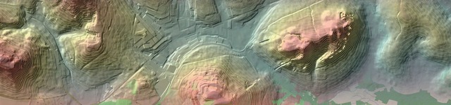
Terrain Models
Digital Terrain Models (DTM) - A planning basis for your projects.
Our many years of experience in international projects, for example in Peru, Kenya, Saudi Arabia, Afghanistan and Indonesia enable us to offer you highly innovative and efficient solutions.
Using modern remote sensing methods, we are ideally equipped to handle tasks in large-scale, inaccessible, and politically unstable project areas. The technologies that we use allow us to generate digital terrain models that are accurate to less than a centimeter. We bundle our expertise in the areas of remote sensing, photogrammetry, cartography, surveying and GIS to provide solutions that are customized to your particular requirements.
Services
We offer you our services in the following areas:
- Consultation
- Data acquisition
- Photogrammetry and remote sensing
- Terrestrial surveying
- SAR - interferometry
- Engineering calculations
- Geodata analyses
- Cartography and GIS
Your contact

Further information
These could be especially interesting for you:
- Digital Terrain Models
- Digital Surface Models
- Stereoscopic Satellite Data
- Aerial Image Data
- UAV / Drone Flight
Learn more about the international IT-Consulting activities of the Fichtner-Group.